Conflict Ecology Damage Monitoring Platform
Sentinel-1 SAR Coherent Change Detection — conflict-ecology.org
Active Monitoring: Last updated March 12, 2026
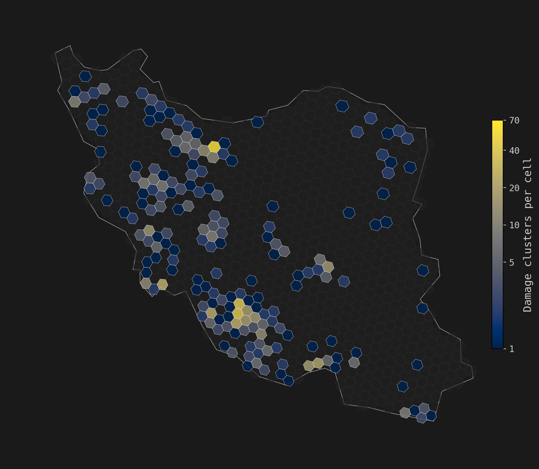
Monitoring structural damage across Iran following the onset of the 2026 Iran War on February 28, 2026. Sentinel-1 SAR coherent change detection is being applied to all post-event acquisitions from March 2, 2026 onward, analyzing all scenes against one year of historical imagery. To date, over 6,000 interferometric pairs have been processed from 24 TB of raw satellite data, with results generated through March 10, 2026.
Loading damage data...
Active monitoring is ongoing, with near real-time processing of new Sentinel-1 acquisitions from downlink. We are currently prioritizing Iran and will extend coverage regionally to Israel, Lebanon, and remaining Gulf countries (Bahrain, Kuwait, Oman, Qatar, UAE) where radio frequency interference conditions permit. An email notification will be sent with each update.
Near real-time satellite-derived structural damage assessments produced using Sentinel-1 synthetic aperture radar coherent change detection. Data are made available for research, humanitarian, and journalistic use under a CC BY-NC-SA 4.0 license.
Citation
These preliminary, near real-time results are adapted from methods described in the following peer-reviewed and in-preparation publications:
- Scher and Van Den Hoek (2025). Science of Remote Sensing
- Scher and Van Den Hoek (2025). arXiv preprint
Contact
For questions about data access or methodology, contact data@conflict-ecology.org.
Enter the access password to continue.
Terms of Use
By accessing these datasets you agree to the following terms:
- No warranty. These datasets are provided "as is" without warranty of any kind. The authors and Oregon State University accept no liability for errors, omissions, or any consequences arising from the use of these data.
- No redistribution. You may not redistribute, republish, or share these datasets or derivative products with third parties without prior written permission from the authors.
- No interactive web maps. You may not publish these data as interactive web maps, tiled map services, or publicly accessible geospatial applications without prior written permission.
- Attribution required. Any use in published work, reports, or media must cite the relevant publications listed on this page.
- Permitted uses. These data may be used for internal research, humanitarian response, and journalistic reporting consistent with the CC BY-NC-SA 4.0 license.
- Accuracy disclaimer. Satellite-derived damage assessments are estimates subject to false positives and false negatives. They should not be used as the sole basis for operational decisions affecting human safety.